


The decline of the periodic El Nino weather pattern, which brings warmer air over the Pacific Ocean, could lead to increased rainfall in large areas of China, meteorological experts said on Wednesday.
"The weakening trend of El Nino has persisted since the start of this year, culminating in its conclusion in May. We are expected to enter La Nina conditions later this summer," Jia Xiaolong, deputy director of China's National Climate Center, said at a news conference on Wednesday.
La Nina contrasts with El Nino by bringing about extensive cooling of ocean surface temperatures in the central and eastern equatorial Pacific Ocean. Their dual influences can lead to increased precipitation.
El Nino began in May last year and peaked in December. Rated as having a moderate intensity, it fueled a spike in global temperatures and exacerbated extreme weather events, Jia said.
China experienced a significantly warmer May this year, with the national average temperature standing at 17.7 C, the highest for that month since 1961, Jia said.
Ko Barrett, deputy secretary-general of the World Meteorological Organization, said on Monday that every month since June of last year has set a new temperature record.
The WMO predicted that between June and August, there is an equal chance of either neutral conditions or a transition to La Nina.
"It is a normal phenomenon for La Nina to closely follow El Nino. Among the six El Nino events that ended in the spring since 1981, five transitioned to La Nina conditions in the coming summer," said Zheng Zhihai, chief forecaster at the National Climate Center.
From June to July, the lingering effects of the El Nino event will give rise to more precipitation in areas like the Yangtze River Basin. In August, it is expected that La Nina will propel the subtropical high northward, leading to above-average rainfall and larger rainy areas in Northeast China and North China, Zheng said.
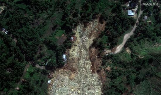
"During the pre-flood season, South China saw above-average precipitation, with Guangdong province recording exceptionally high rainfall," he said, adding that this year's flood season will be characterized by more floods than droughts, and special attention should be paid to disasters like flooding and landslides.
During the summer, as La Nina develops and El Nino recedes, the tropical monsoon trough will move westward and northward, potentially triggering anticyclones in the Philippines and resulting in fewer typhoons, Jia said.
"It is expected that this year will see 21 to 24 typhoons in the northwestern Pacific Ocean and the South China Sea, slightly fewer than the typical level of 25. Among them, six to eight typhoons are expected to make landfall in China, close to the typical level of seven," said Dai Kan, deputy director of the National Meteorological Center.
The typhoons are expected to be of strong intensity and mainly affect the eastern areas of South China and the coastal areas of East China. It is possible that one or two will move northward, potentially making landfall or bringing severe impacts to North China, Dai said.


 京公網安備 11010202009201號