


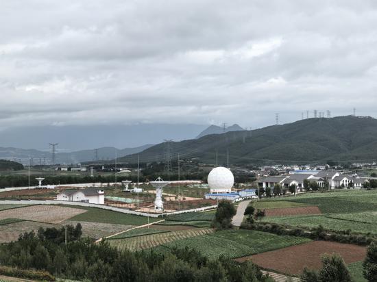
A picture of the Lijiang Satellite Ground Station, one of the ground stations of the Chinese Academy of Sciences Aerospace Information Innovation Research Institute, in Yunnan province. (Photo provided to chinadaily.com.cn)
China has achieved real-time reception of satellite data across all its national territory and 70 percent of the land area in Asia since September, when a satellite ground station located at an altitude of 2,827 meters in Yulong Naxi autonomous county, Lijiang, was completed and put into operation.
"In other words, when a satellite passes over China, the data it collects is received by the ground station and transmitted in real-time to the Beijing headquarters for distribution to relevant units or research departments, enabling them to access the data promptly," said Tang Mengyue, head of the Lijiang Satellite Ground Station at the Chinese Academy of Sciences Aerospace Information Innovation Research Institute.
Since the establishment of the first ground station in Miyun district, Beijing, in 1986, the China Remote Sensing Satellite Ground Station has built a network of satellite receiving stations in Kashgar, Northwest China's Xinjiang Uygur autonomous region; Sanya, South China's Hainan province; Lijiang, Southwest China's Yunnan province; and Mohe, Northeast China's Heilongjiang province, covering the four basic directions.
Real-time data transmission holds significant importance. For instance, in the case of environmental disaster monitoring satellites, such as forest fires, earthquakes, or oil spills, timely data allows relevant departments to make faster and more accurate assessments and decisions, allowing them to respond promptly and minimize the impact of disasters.
"These aspects may not be directly noticeable in our daily lives, but they are indispensable for the smooth functioning of society and our livelihoods," Tang said.
Equipped with remote sensing satellites carrying different payloads, these satellites can be used for various purposes such as resource exploration, urban planning, environmental monitoring, disaster mitigation, and space exploration.
"Before 1986, scientists who needed to use remote sensing satellite data had to purchase it at a high cost from countries such as the United States," Tang noted. "But now, China's satellite ground station receiving technology has full independent intellectual property rights."


 京公網安備 11010202009201號