


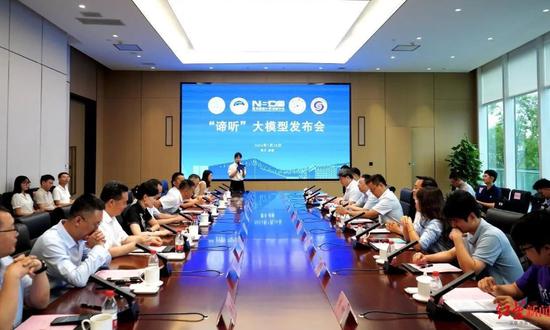
A press briefing to introduce "DiTing" is held in Chengdu, Southwest China’s Sichuan Province on July 28, 2024. (Photo/Chengdu science and technology bureau’s official WeChat account)
The world's first large-scale seismic data processing model with 100 million parameters called "DiTing" has been officially released, a significant advancement for China in key technologies in seismology, according to the Chengdu science and technology bureau in Southwest China's Sichuan Province on Monday.
The model was developed by the National Supercomputing Center in Chengdu in cooperation with the Institute of Geophysics of the China Earthquake Administration and Tsinghua University, the Xinhua News Agency reported.
In September 2023, the National Supercomputing Center in Chengdu partnered with the Institute of Geophysics of the China Earthquake Administration to establish the joint laboratory for research into earthquake large-scale model innovation application.
They launched the training of the "DiTing" model with researchers from Tsinghua University and the Institute of Geology and Geophysics, Chinese Academy of Sciences, to advance artificial intelligence algorithms in seismology and research in earthquake monitoring and forecasting services, said Guo Li, chairman of Chengdu Supercomputing Center Operation Company, according to the supercomputing center on Monday.
The "DiTing" dataset is the first and one of the largest seismic AI training datasets for seismology with the most comprehensive sample types and labeling, said the center.
Researchers have developed a seismic wave model with 100 million parameters in the half-year study in the joint lab, which is now ready for use, and a version with 1 billion parameters is expected to be completed pre-training by August 2024, supporting earthquake prevention and disaster reduction efforts, according to the developers.
In future, the model could be applied in fields such as mine seismic monitoring, shale gas exploitation, urban underground space structure detection, underwater earthquake monitoring and others, according to the developers.


 京公網(wǎng)安備 11010202009201號