


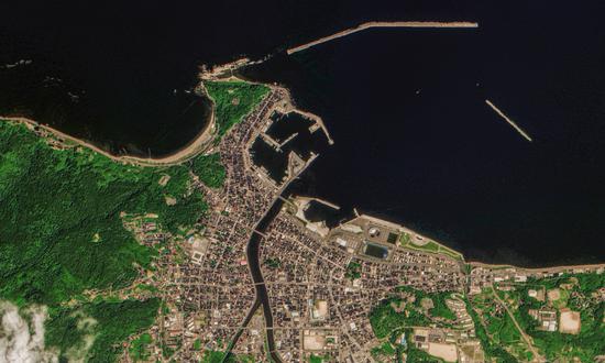
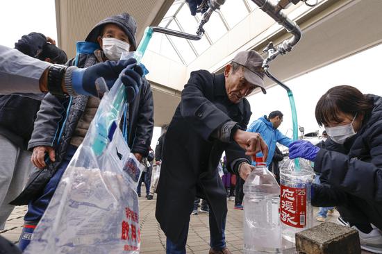
Satellite image of the earthquake, the most severely damaged houses in Wajima city, Ishikawa Prefecture. (Photo/Courtesy of Chang Guang Satellite Technology Co)
According to post-earthquake satellite images released by Chang Guang Satellite Technology Co, a domestic commercial satellite, on Thursday, the earthquake in the Noto region, Ishikawa prefecture in Japan has caused severe damages to local buildings. Nearby rivers have become turbid, and some sea areas have turned into land.
Latest statistics released by Ishikawa prefecture showed that the earthquake has caused 213 deaths, 567 injuries, with 52 people still missing in the prefecture, Japanese media reported on Thursday.
Also on Thursday, the Japanese government decided during a cabinet meeting to classify the Noto Peninsula earthquake as a "severe disaster" and adopted plans to strengthen reconstruction and recovery work, as well as increase the subsidy rate for road and farmland recovery projects. Satellite images of the region provided by Chang Guang Satellite illustrated the "severe disaster."
The satellite images were taken by the Jilin-1 High-Resolution 03D16 satellite on January 5, and were compared with images obtained by the Jilin-1 Wideband 01A satellite in 2023. The comparison shows that coastal buildings in Wajima were severely affected by the earthquake and secondary disasters, with significant collapses of houses, bridges and roads, the Global Times has learned.
Part of the city center was scarred from fire, with a burnt area of approximately 48,000 square meters. Sediment on the riverbed was stirred up by the earthquake, causing the water to become turbid due to soil liquefaction and other factors. Some sea areas turned into land after the earthquake.
Latest observation results released by the Geospatial Information Authority of Japan, a subsidiary of the Ministry of Land, Infrastructure, Transport, and Tourism, on Tuesday, showed that the Noto Peninsula has experienced significant crustal movements after the strong earthquake. Among them, the city of Wajima experienced the largest movement, with a horizontal displacement of about 2 meters to the southwest and an uplift of about 1.3 meters. Another heavily affected area, Suzu city, moved 94.6 centimeters to the southwest and uplifted nearly 90 centimeters, while Anamizu town moved 93.5 centimeters to the northwest and uplifted about three centimeters.


 京公網安備 11010202009201號