


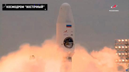
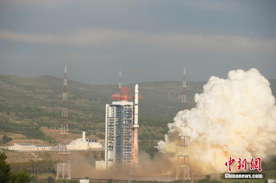
China successfully sent the Land Exploration-4 01 satellite, the world's first high-orbit synthetic aperture radar (SAR) satellite, into a preset orbit via a Long March-3B carrier rocket from the Xichang Satellite Launch Center in Southwest China's Sichuan Province at 1:26 am on Sunday.
The Land Exploration-4 01 satellite is a remote sensing research satellite listed in the country's Medium and Long Term Development Plan for Civilian Space Infrastructure (2015-2025.)
The satellite operates in an inclined geosynchronous orbit and is equipped with a synthetic aperture radar payload with high resolution, wide coverage, multiple modes, and lightweight advantages, the CNSA revealed.
Compared with low-orbit satellites and optical satellites, the Land Exploration-4 01 satellite combines the advantages of a short revisit period and large imaging swath in high-orbit observation with the advantages of microwave observation that is not limited by weather conditions (all-weather) and not limited by lighting conditions (all-day), which can improve the accuracy and efficiency of identifying abnormal changes in weather and enhance the nation's comprehensive disaster prevention and control capabilities, the CNSA said in a press release sent to the Global Times on Sunday.
With the satellite now in orbit, it will enrich China's key regional observation methods and provide all-weather and all-day observation of China's territory and surrounding areas, meeting the needs of disaster prevention and reduction, earthquake monitoring, land and resources surveying, as well as applications in industries such as the marine, water conservancy, meteorology, agriculture, environmental protection, and forestry industries, according to the press release.
State departments led by China's Ministry of Emergency Management, including the Ministry of Natural Resources, Ministry of Water Resources and China Meteorological Administration, are key users of the satellite and they will carry out construction of ground systems and operation systems according to their specific needs.
The satellite was developed by the China Academy of Spacecraft Technology (CAST.)
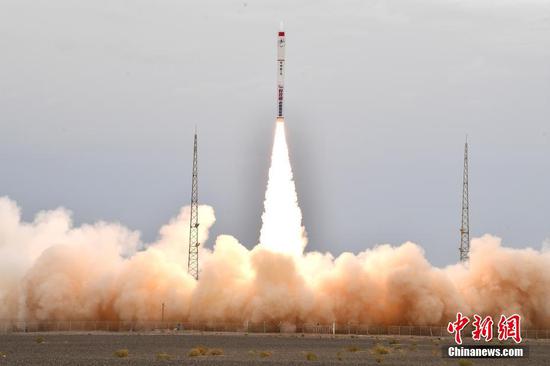
This was the second disaster prevention-related satellite launched within a week by China, following the codenamed Environmental Surveyor 2F, launched by a Long March 2C rocket from the Taiyuan Satellite Launch Center in North China's Shanxi Province on Wednesday.
Also developed by CAST in Beijing, the satellite is tasked with using its synthetic aperture radar to obtain images and data to support disaster prevention and mitigation, ecological monitoring and emergency response efforts. Its users are the Ministry of Emergency Management and the Ministry of Ecology and Environment.
On Sunday, space industry observers hailed the country's innovative strength in the space domain, which they say has been increasingly creating value in civilian applications and shows that the country's space development upholds the concept of "putting people first."
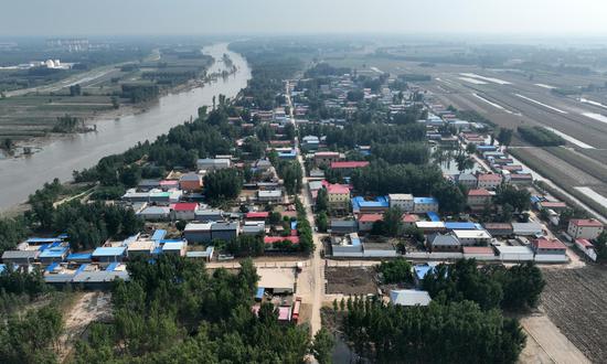
During the recent heavy rainfall that impacted the Beijing-Tianjin-Hebei region in North China as well as Northeast China's Heilongjiang and Jilin provinces, 16 satellites, including Gaofen-3 remote sensing satellites, were deployed to provide rapid imaging services to assist disaster monitoring, according to the state-owned aerospace giant China Aerospace Science and Technology Corporation (CASC) on Saturday.
The CASC told the Global Times on Sunday that these near real-time satellite images taken over the hardest-hit flood areas have provided scientific data services to support disaster relief work.


 京公網安備 11010202009201號