


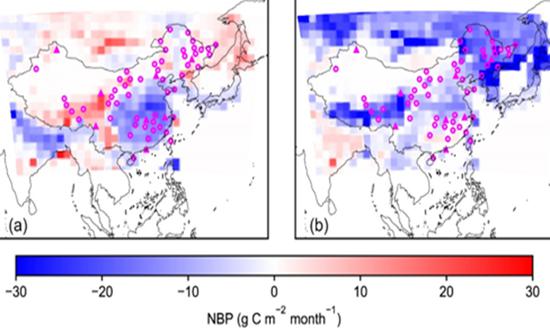
(Photo/Courtesy of Chinese Academy of Sciences)
Chinese scientists from the Institute of Tibetan Plateau Research, Chinese Academy of Sciences, proposed a ground station layout plan for observing atmospheric CO2 concentration. This plan is expected to play a key supporting role in formulating emission reduction and carbon sequestration policies and measures, as well as achieving carbon neutrality goals in China, the Global Times learned from the CAS on Wednesday.
The proposal was issued by associate researcher Wang Yilong and researcher Tian Xiangjun from the Institute of Tibetan Plateau Research, CAS, along with several collaborators by optimizing the selection of atmospheric carbon dioxide (CO2) observation sites. It has been available online in the Science Bulletin since July 11.
An accurate estimate of the size of land carbon sink is essential for guiding climate mitigation actions to fulfill China's net-zero ambitions before 2060, the article noted.
The atmospheric inversion is an effective approach to provide a spatially explicit estimate of surface CO2 fluxes that are optimally consistent with atmospheric CO2 measurements. However, the atmospheric inversion of China's land carbon sink brings enormous uncertainties, with one major source arising from the poor coverage of CO2 observation stations. The study suggests that it is necessary to establish 60 atmospheric CO2 observation sites in China, and by assimilating the observation data, the accuracy of estimating the terrestrial carbon sink in China using atmospheric inversion methods will reach the advanced level of Europe and the US, according to a release CAS provided to the Global Times.
The first author of the article, Wang Yilong, explained that the terrestrial ecosystem carbon sink is an important support for China to achieve carbon neutrality. Clarifying the size and spatial-temporal distribution of the terrestrial ecosystem carbon sink in China is crucial for understanding the current status of carbon sinks and estimating their future potential.
Atmospheric inversion is a method for measuring carbon sinks, which is based on atmospheric CO2 concentration observation data, atmospheric transport models, and anthropogenic CO2 emission inventories. Currently, China's high-standard ground CO2 observation sites are relatively sparse, which is a bottleneck for estimating the carbon balance of China's terrestrial ecosystems using atmospheric inversion. Expanding and optimizing the existing observation network, selecting new atmospheric CO2 observation sites through scientific and economic methods, and improving the accuracy of estimating China's terrestrial carbon sink are urgent issues to be addressed.
This study adopts an optimization approach to traverse all model grids and find the optimal locations for additional sites based on the existing sites. Through iterative processes, a total of 52 additional sites were selected, along with the existing 8 sites, to form a ground station observation network for atmospheric CO2 concentration in China.
The research results show that based on the existing sites, it is necessary to add CO2 observation sites in the southeastern, northeastern, northern China and the Qinghai-Tibet Plateau regions with high vegetation productivity during the growing season. If 30 observation sites are established in China, the uncertainty of carbon sink estimation can be reduced from 1 billion tons of carbon per year to 300 million tons of carbon per year. If 60 observation sites are established, the uncertainty can be further reduced to 200 million tons of carbon per year. The researchers further demonstrated that this observation network has wide applicability, providing high estimation accuracy for China's carbon sink when different inputs and configurations are used for inversion.
The proposed site locations in this study also include areas with low satellite coverage and complex terrain, forming an effective complement to satellite observation data. These sites will become an important part of the sky-ground integrated carbon observation system, serving the inversion and accurate accounting of CO2 balance in China.
This research was supported by the Second Comprehensive Scientific Expedition to the Qinghai-Tibet Plateau, the National Natural Science Foundation of China, the National Major Science and Technology Infrastructure Project (EarthLab), and the Youth Innovation Major Project of the National Key Laboratory of the Tibetan Plateau Earth System and Resource Environment.


 京公網安備 11010202009201號