


A Chinese aerial remote sensing system has obtained effective mountain glacier detection data through an ongoing combined detection experiment.
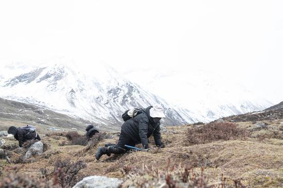
The Chinese Academy of Sciences (CAS) and Wuhan University is conducting a sky-ground scientific experiment to test the condition of glaciers in the Haibei Tibetan Autonomous Prefecture in northwest China's Qinghai Province.
The experiment has applied radars in three bands -- P-band, L-band and Very High Frequency (VHF) -- and undertaken 11 flights, among which seven carried out tomography and interferometric imaging and four conducted perspective imaging.
A total of 4.6 terabytes of valid data has been obtained.
The experiment also involves the visible light and lidar flight observation of the ice surface, the calibration of instruments used to analyse the surface of the ice, the measurement of glacier thickness using ground-penetrating radar, and extra-long visual distance three-dimensional cloud imaging.
The obtained data shows that three-dimensional reconstruction can reflect the trend of glacier surface elevation and the boundary lines between ice and atmosphere, and between glacier and bed rock. Researchers used the data to target the location of an electrical anomaly that had been artificially placed at a depth of 80 meters in an ice core borehole.
The experiment has verified a comprehensive glacier characteristics observation technique and tested the feasibility of the joint P-band, L-band and VHF experiment. It has also obtained effective data, which will be shared by China's National Tibetan Plateau Data Center.
Wu Yirong, head of the CAS Aerospace Information Research Institute, acknowledged that the experiment's VHF radar constitutes the first aerial glacier detection payload independently developed by the institute.
It is also the first time the domestic MA60 remote sensing aircraft has flown above 4,500 meters in a mountainous area.
The experiment is of great significance to the development of glacier detection technology in China and scientific research on global changes, said Gong Jianya, head of the School of Remote Sensing Information Engineering at Wuhan University. He said that it will provide an important reference for the scientific verification of civilian P-band synthetic aperture radar satellites.
The experiment began on March 20 and is scheduled to conclude by mid-May.


 京公網安備 11010202009201號