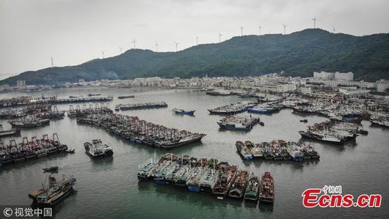
Every reef and ship to be put under surveillance to deal with emergencies
South China's Hainan Province will build its first commercial satellites to monitor the South China Sea, which would play a part in national defense, marine salvage operations, and assist in the development of countries in the?Belt and Road?initiative, experts said.
Work on the prototype of the first three satellites of Hainan-1 Earth Observation Satellites has begun and the satellites are expected to be launched by 2019, according to a report sent by Sanya Institute of Remote Sensing of Chinese Academy of Sciences, the program's sponsor, to Global Times on Wednesday.
The satellites will be able to observe the South China Sea "within days compared to the current two to three months," Institute director Yang Tianliang told the Global Times on Wednesday.
The Hainan-1 satellites will carry a camera and an Automatic Identification System (AIS).
"The Hainan-1 satellites will monitor every reef and ship within the South China Sea, which can help provide an accurate and quick response in an emergency," the report said.?
Hainan-1 satellites are part of a series of satellites, including six Hainan-1 satellites, two Sanya-1 Earth Observation Satellites and two Sansha-1 Earth Observation Satellites, which will be launched within the next four to five years, the report said.
The series of satellites will be able to observe the South China Sea and other important areas every day, Liang said.
They will be also capable of monitoring areas between 20 to 30 degrees north and south from the equator, Liang noted.
"This can cover important areas such as the Indian Ocean and part of the Strait of Malacca," said Chen Xiangmiao, a research fellow at the Hainan-based National Institute for the South China Sea.
The satellites will be of great importance in terms of defending territorial sovereignty, marine exploration, domestic fisheries security and cooperation with surrounding countries on marine issues, Chen said.?
The technology will also give China an advantage in negotiating the demarcation of the sea, Chen noted.?
The last two satellites will be launched in 2021 as scheduled.
Data on passing ships, reefs and water quality within the sea will be shared with other countries, Liang said.?
The satellites will also be capable of monitoring the environment and disasters, and the information "can be readily provided to less developed countries along the Belt and Road initiative, if needed," Liang said.?
China has built a satellite receiving station in Sanya, Hainan Province, and has been operating since 2010. The station receives, records and transmits data from satellites.