 Web Editor: Zang Kejia
comment
Web Editor: Zang Kejia
comment
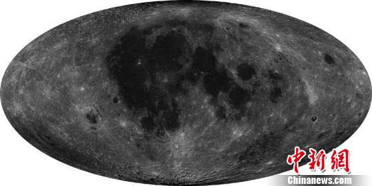
Beijing (CNS) ¨C A set of images that fully captures the details of the lunar surface at seven-meter resolution have been released by the State Administration of Science, Industry and Technology for the National Defense of China (SASITND), in Beijing on February 6.
The images were recorded by China's second unmanned moon orbiter, the lunar probe Chang'e-2.
China is the first country in the world to obtain high resolution images of the lunar surface at seven-meter quality, according to SASITND. This marks another significant scientific milestone in China's lunar exploration project.
A total of 746 images to this standard cover 100-percent of the moon's surface. Chang'e-2, equipped with a CCD stereo camera, started its documentation mission on October 24, 2010. As of May 20, 2010, it had access successively to the images and data streaming from points 100 miles and 15 miles above the moon's surface along the 607 Orbit.
The satellite is now transiting the second Lagrange Point more than 1.5 million kilometers away from Earth.

Copyright ©1999-2011 Chinanews.com. All rights reserved.
Reproduction in whole or in part without permission is prohibited.


