


The Chinese government will actively seek to share, promote and apply its first set of national mapping information data through institutions and companies to better serve the public, Kurex Mexsut, deputy head of the National Administration of Surveying, Mapping and Geoinformation, said on Monday.
He made the statement during a State Council news conference in which the results of China's first geographical census were released.
"With the coming of the smart age, survey and mapping results are increasingly used in many areas, not just in the government's crucial development strategy but in the daily lives of the public," he said.
"When we get up in the morning, we can use various apps on our cellphones to find good places to eat or interesting places to have fun, and we can use a navigation app to drive to the destination," Mexsut said.
"As a person who has been in the surveying and mapping industry for decades, I can say that when I was young I never expected it to develop to this stage."
He said the administration will establish a data sharing mechanism and an information services platform to maximize the openness and use of their data. Meanwhile, it will actively cooperate with different departments to provide public data products and customized data services to companies and institutions.
"We would like to regularly publish the monitoring report on national geographical conditions to the public and the market, aiming to better serve economic growth and scientific decision-making," he said.
Ye Xin, deputy general manager of wearable business devices for Beijing Watchdata Co, said the company welcomes the mapping data.
"We used to cooperate with other companies to gain urban data for our business use," Ye said. "If the government can share it, we would love to cooperate with the government. However, we are not clear about where and how to get the data. I hope the government can provide a detailed description of the process."
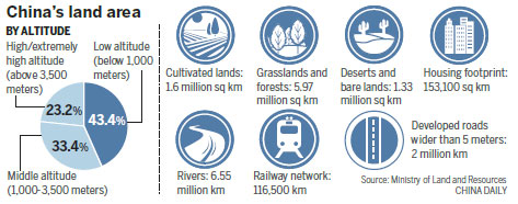
During the news conference, Mexsut, who is also director of the State Council's Office of the Leading Group for the First China Geography Census, released the results of the census, which took three years to compile.
The results include overall information about China, as well as precise information on geographical conditions, he said.
At present, such data are used in many ways, with applications extending to poverty alleviation, unified real estate registration, urban water treatment and the campaign against illegal land use.
 ����
����


