China started to run its own satellite positioning system, Beidou, on Tuesday as the country climbed the global tech ladder and challenged the monopoly of the West.
Beidou, or Big Dipper, the domestic version of the US Global Positioning System (GPS), started providing navigation, positioning and timing data on a pilot basis to China and the neighboring area for free on Tuesday, Ran Chengqi, director of the China Satellite Navigation Office, said.
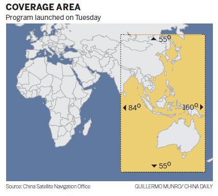
The system, with 10 orbiting satellites, covers an area from Australia in the south to Russia in the north. Signals can reach the Xinjiang Uygur autonomous region in the west and the Pacific Ocean in the east, Ran said.
With six more satellites to be launched next year, the system will cover a wider area and eventually the entire globe by 2020 with a constellation of 35 satellites, he said.
The accuracy of the positioning service will also improve as more satellites orbit.
During the trial run Beidou can offer positioning to within 25 meters but when the system is officially launched next year accuracy will be enhanced to within 10 meters, he said.
With the system operational China is the third member of an elite group, along with the US and Russia, to develop a satellite navigation system.
The US spent 20 years and more than $20 billion on the GPS. Completed in 1994, the system has 24 navigation satellites and is widely used around the world.
Beidou has its own unique features, Ran said.
"It not only tells users where they are and what time it is but also allows users to tell others the information through short messages," Ran said, adding that this feature is being considered by other systems.
Russia's Glonass system achieved a 24-satellite constellation in 1996 but succumbed to funding problems.
The rebuilding of the Glonass system is almost finished and Russian media reported that the system resumed service earlier this month.
The European Union and the European Space Agency are building the Galileo satellite navigation system. Japan and India also intend to build independent regional navigation systems.
"Countries build their own systems because owning an independent satellite navigation system is important to economic development and national security," said Pang Zhihao, deputy editor-in-chief of the monthly publication Space International.
There have long been concerns that the US might take its dominant GPS offline in certain international emergencies.

Copyright ©1999-2011 Chinanews.com. All rights reserved.
Reproduction in whole or in part without permission is prohibited.


